NASA: Ebre River Delta 'shape and form no longer controlled by the river, but by sea waves'
Satellite images document erosion caused by lack of sediment flow and climate change
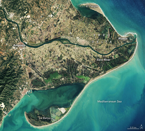
Southern Catalonia's Ebre River Delta, one of the Mediterranean coast's most extensive wetlands, is home to a rich ecosystem with hundreds of plant and animal species as well as thousands of hectares of rice fields.
Designated a UNESCO Biosphere Reserve in 2013, the area known for its marshes and migratory birds is at risk of disappearing due to climate change, which has led to increasingly frequent extreme weather events and rising sea levels.
According to a recent NASA Earth Observatory article by Sara Pratt, "the shape and form of the delta is no longer controlled by the river, but by sea waves" which have forced the shoreline to retreat "by several hundred meters."
Satellite images taken in 1984 and 2021 by Lauren Dauphin using Landsat data from the U.S. Geological Survey document severe erosion in the area that is home to some 62,000 inhabitants.
This has been exacerbated by a lack of sediment flow caused by the dams that were built along the river to supply water for irrigation as well as to generate hydroelectric power.
The narrow sandbar known as 'Barra del Trabucador' that connects the 'Punta de la Banya' sand spit to the delta was flooded by storm Gloria in January 2020 and a year later by storm Filomena, as were thousands of hectares of rice fields and dune fields on the beaches.
The receding coastline "illustrates the hard choices to come for communities facing rising seas —try to hold back the ocean or manage the retreat," Pratt writes.
Spanish authorities announced plans to buy land to create a buffer zone, but many locals oppose this and instead favor protecting the delta by bringing in sand and building sea walls.